Friday 31 May 2013

Fisherfield Five plus One

The path up from Carnmore as the mist breaks

Fuar Loch Mor from the path

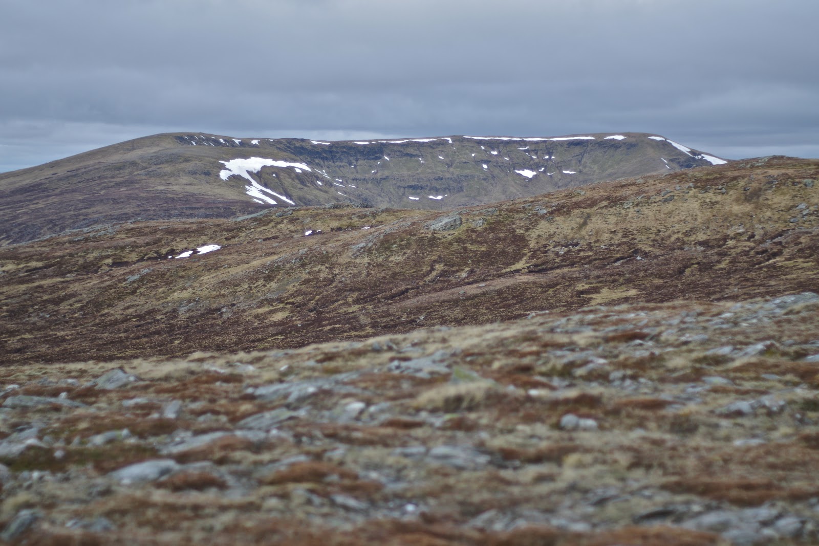
Beinn Dearg Mhor and An Teallach from Ruadh Stac Mor

Cave at the bealach below Ruadh Stac Mor

Beinn Lair from A' Mheaghdean

An Teallach and Ruadh Stac Mor from A' Mhaighdean

Beinn Tarsuinn ridge

Sgurr Ban and Mullach Mhic Fhearchair from Beinn Tarsuinn

Mullach Mhic Fhearchair summit

An Teallach from Sgurr Ban

An Teallach from Gleann na Muice

Beinn Dearg Mhor

Ruadh Stac Mor and A' Mhaighdean

Ruadh Stac Mor and A' Mhaighdean from Chaisgean Mor

A' Mhaighdean

Beinn Lair from Beinn a' Chaisgein Mor

Summit at Sunset, Beinn a' Chaisgein Mor

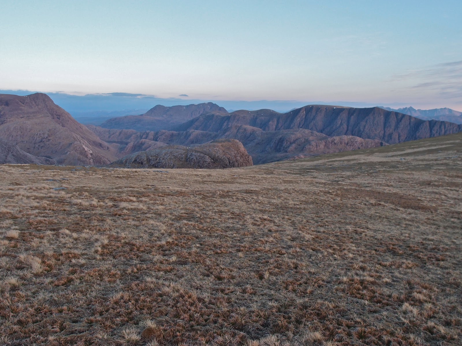
Ben Lair and the Torridons on the final descent to Carnmore

Thursday 30 May 2013

Ascent:        2655 metres
Distance:      28 kilometres
Time:           13 hours 2 minutes

m    Ruadh Stac Mor                    918m      1hr 59mins
m    A' Mhaighdean                      967m     3hrs 18mins
m    Beinn Tarsuinn                      937m     5hrs 29mins
m    Mullach Mhic Fhearchair     1018m     6hrs 44mins
m    Sgurr Ban                               969m     7hrs 21mins
c     Beinn a' Chaisgein Mor          856m    11hrs 47mins 

The Fisherfield Five, as we now must call them following the unfortunate relegation of Beinn a' Chlaidhemh from Munro status last year,  provide one of the longest days in any Munro round. I had previously climbed them twice in each direction starting from the Shenaval bothy or from wild camps after a first day driving up and climbing An Teallach. I had had two near-perfect days in 1990 and 1995 and one glorious morning which erupted into a fierce and prolonged downpour in the late afternoon. The other occasion was when I took my teenage son along and after climbing An Teallach on the way in, a fierce gale and a downpour had forced us to spend the night in a cave at the bealach between Ruadh Stac Mor and A' Mhaighdean . I was under no delusion that even in the forecast good weather this would be a long and tough day in this mountain nirvana.

Fisherfield is a very special place as I was told when I met the late W.H. Murray in 1995 at the premiere of the film Rob Roy in Clydebank. He had written the book on which the film was based and on hearing that I was going to Fisherfield the next morning, he gave his apologies to the queue for book signing behind me and regaled me with his tales of Shenaval, An Teallach and Beinn Dearg Mhor, all of them his favourite haunts. He urged me to climb Beinn Dearg Mhor as well as An Teallach and the Fisherfield six munros. We managed them all in two long hard days including the drive up.  He was a remarkable character as well as a talented writer and he was right about Beinn Dearg Mhor which remains one of my favourite Corbetts.

I was with my old hill running partner, Keith, and after a 4pm start, the long walk in from Poolewe to Carnmore via the Corbett of Beinn Airigh Charr the previous evening we had not turned in until 11:30pm.  It was almost 9am before we set out from the tents in the morning mist. As we climbed the stalker's path from Carnmore up to the Lochan we emerged from the mist at about 400 metres and the entire collection of Fisherfield mountains loomed into view. It was a magical reunion with what must surely be Scotland's wildest and most remote mountains.

The track up to the bealach between Ruadh Stac Mor and A' Mhaighdean is well-graded and at the top, we dumped our rucksacks and headed up the steep scree slopes of Ruadh Stac Mor.  We followed a faint path through the rocks until we reached the higher slopes when a more discernable path through the scree was followed. The red sandstone provides a good grip and we were on the summit in no time. We could see a party of four on the summit of A' Mhaighdean and the views to Beinn Dearg Mhor and An Teallach provided a scintillating backdrop to the north. This was a day to stop and loiter on summits. We did so all day, maybe a little too complacent about our ability to get around all of Fisherfield in a day now we were in our sixties

We descended through the rock and scree to the bealach where I located the cave where Gregor and I had once spent an uncomfortable night in gale-force winds and rain. I had had to erect the tent inside the cave to keep the water off us and it was sheer bloody-mindedness that drove us around the Fisherfield six that day. The steep climb up to A' Mhaighdean today was a jaunt into magical mountainscapes.  When we reached the summit, possibly with the finest views of all Munros we decided to take a break in the sun for half an hour to soak in the views over a leisurely lunch, something that we never normally entertain. There is a long easy descent down an open meadow to the bealach.  We were able to top up with water before tackling the next three munros.

The climb up Beinn Tarsuinn (or in the other direction the climb up A' Mhaighdean) is the spoiler of the Fisherfield hills. The views are hidden, the ground is mainly bog and heather and it is a 400-metre uphill slog in either direction. The summit ridge is a different matter, it is airy with great views and provides an easy and enjoyable scramble. The summit is a balcony for panoramas that eclipse almost anywhere else: the Torridons, Slioch, Fisherfield, An Teallach and the sublime Beinn Dearg Mhor. I finished my food and we set out for the descent and then undercut the outlier of Meall Garbh before starting the steep and relentless ascent of Mullach Mhic Fhearchair. Keith went out to take in the eastern tops, he always climbs all Munro tops, even those that had been deleted. My own objective was to climb the remote Corbett of Beinn a' Chaisgein Mor at the end of the day, so we had agreed to split at this point.

I wasted no time and descended the white powdery, rocky and steep path before climbing the slightly easier path to the pile of rocks that goes under the name of Sgurr Ban. As I reached the summit I could see Keith summiting on Mullach. There was no sense in waiting as Keith was going to take in the deleted Munro, Beinn a' Chlaidheimh, so I started the descent down the huge area of quartzite blocks before deciding that there must be a better way and took a direct route for Loch a'Bhrisidh. There were still some snow patches and beyond that a combination of large blocks and heather that was hard on the feet and legs and even more so on the concentration. It continued in this vein for 500 metres of descent all the way down to Gleann na Muice but with peat bogs added to the cocktail of difficult ground conditions.

Wading the river was a reward: cool feet and then at the other side more accommodating grassy slopes leading to a bealach northeast of Rudh Stac Beag at 524 metres. From here the views of Beinn Dearg Mhor were mesmerising and An Teallach was not bad either. I dropped down to 425 metres to reach the stalker's path and then climbed steadily until reaching the couple of lochans from where I began a long ascent over convex slopes which went on for several kilometres until I reached the summit of Beinnn a'Chaisgein Mor at about 9pm. It was a memorable evening with clear visibility of Scotland's finest mountains and wonderful sea views came into play. Beinn Lair looked most impressive and this was on the menu for the next morning.  I was also pleased that after another wonderful day in Fisherfield, it would take less than an hour to reach the tent

I resisted returning by the same route, time was getting late, and I figured that I could descend by a steep gulley to Carnmore if the Harvey Map was right and the rock faces were on only one side of the burn. It was not an easy descent but I was down at the tent which was visible below just before 10pm. Keith had not arrived back so I presumed that he must have decided to climb the Corbett as well. I had finished my supper and was ready to turn in on a benign evening when Keith arrived at the back at 11pm. He had indeed done the Corbett and completed a 14-hour stint on the hills. Fisherfield exhausts as much as it inspires, sleep was calling.

Beinn Airigh Charr

Beinn Airigh Charr from Kernsay

Moorland path, Beinn Airigh Charr ahead

Primroses at 550 metres

At 600 metres on the ascent

Beinn Airigh Charr summit final approach

Slioch

 Fionn Loch causeway with A'Mhaighdean as the dominant peak

Looking south east to the Torridons

Loch on the walk in to Carnmore, Ben Lair ahead

Wednesday, 29 May 2013

Ascent:       1065 metres
Distance:    24 kilometres
Time:          6 hours 4 minutes

c  Beinn Airigh Charr      791m    3hrs 25mins    

Arriving back from London late on Tuesday, I had a phone call from Keith Adams about the possibility of a trip to Fisherfield in the morning. He was nearing the end of his fifth round and this was the last two/three-day walk that he had to do. I immediately said yes, this is one of my favourite walks, but he then called round to the house after 10:00pm on his way back from a day walk to say that he might not be able to make it and could we do a walk nearer home. The weather was to be good in the northwest for two days and I wanted to make the best of it and started making alternative plans. Keith arrived on Thursday morning and the excellent weather forecast had converted him to the Fisherfield plan. We loaded my car and set out just after 10:00am.

After stopping at Inverness for diesel and some macaroni cheese, we were going to be in the wilderness for 48 hours, we drove on to Poolewe. The sun was shining as we drove past Loch Maree and Slioch was a shimmering sentinel. The coastal scenery from Gareloch to Poolewe was stunning and it felt like we were in for a great adventure. There is a good parking area just over the bridge in Poolewe. We repacked our rucksacks and set off at about 4pm for the long trek into Carnmore, where we intended to wild camp for a couple of nights.

We walked along the road beside the river Ewe which was sparkling in the afternoon sun. There is a good road/track for the first 5 kilometres to Kernsary where perfect green pastures fall to the loch side and deer graze like domestic herds. Shortly afterwards a track leads into the forest and there is a fairly boggy couple of kilometres to negotiate before emerging on a good moorland path that snakes along past numerous small lochans for 8 or 9 kilometres to Carnmore.

I had suggested that we climb the Corbett, Beinn Airigh Charr, on the way to Carnmore. It looked tempting, so we cut across the moorland and began a fairly direct ascent after dropping our rucksacks. Rather than taking the path, we continued to climb at a steady rate cutting underneath the 705m top, walking through a hillside of yellow primroses and making for the grass and scree slopes to the west of the summit. For the first of many occasions in the next 24 hours, we were blessed by the perfect conditions. I took photos and sent messages, surprised that phone reception was better here than in many urban areas.

We set out back at a strong pace hoping to pick up the sacks at 8pm which would mean we could reach our camp location before 10pm. Stupidly I had put my phone down at the summit after sending pictures to friends whilst I took photos with my camera. I only realised this when down to 600 metres, and I could not find my phone for another picture opportunity. I hollered to Keith who was ahead that I was returning to the summit where I spent 10 minutes searching for my phone but to no avail. I must have dropped it on the descent. It was almost 8:30pm by the time I reached the rucksacks. Keith had been waiting for half an hour and was starting back up the hill to look for me. I had climbed an extra 170 metres and walked 2 kilometres on my futile search.

We sharpened our pace for what was another couple of hours on the track. Initially, the lochans, the magnificent scenery and the sense of exhilaration fuelled our walking but it dragged on and by the time we crossed the causeway between Fionn Loch and Dubh Loch, we were relieved to call it a day. There is a short climb and then some good camping spots near to the house and barn at Carnmore, four other tents were pitched. We had enjoyed some spectacular views and it looked like the weather would hold. A thrifty supper of soup and cous cous and I was ready for sleep.

The loss of my phone had a happy ending when I arrived home on Friday. Aileen had taken a random phone call from someone who had found the phone near the summit. He had flown home to Southampton and, having obtained my address from Aileen, put the phone in the post. It arrived on Saturday morning, a tribute to the honesty and kindness of outdoor enthusiasts and the speed and efficiency of Royal Mail. It also saved friends the agony of sitting at work on Thursday and seeing my photos of Fisherfield in all its glory appear in their inboxes. One of the joys of retirement.

Wednesday 22 May 2013

Cam Chreag and Maol a' Mhuic: Glen Lyon's reclusive hills

Cam Chreag ridge
Cam Chreag the approach track

Stuc an Lochain above Loch an Daimh dam


Ben Lawers group from Cam Chreag

Meall Buidhe from Cam Chreag
Towards Schiehallion and Carn Gorm from Meall a' Mhuic


Ben Lawers group from Meall a' Mhuic

Over Loch Rannoch to the distant Cairngorms
Ascent:     950 metres
Distance:   16 kilometres
Time:        4 hours 46 minutes

c  Cam Chreag         880m    1hr   50mins
g  Meall a' Mhuic     746m    3hrs 55mins

I had planned to climb Garbh Bheinn in Ardgour and was packed and ready to leave at 7:30am to catch the bus to Corrour from Crianlarich. I then checked the Met Office forecast and it seemed to suggest clouds below the summits. I had always promised myself a good day for Garbh Bheinn so another plan was needed. I looked at the maps of my corbetts and grahams on walkhighlands and discovered a Graham (hill between 2000ft and 2500ft with a drop of at least 500ft) reasonably close to my last unclimbed Corbett, Cam Chreag, in Glen Lyon. The weather looked more promising than in the west so I headed for Glen Lyon taking the road over the bealach between the Tarmachan and Ben Lawers.  I parked at the excellent car park provided by the Meggernie Estate at Innerwick. The estate has upped its game in recent years and the helpful information boards and toilets make Glen Lyon a welcoming as well as beautiful place. It had been an estate that was hostile to walkers in the 1990's.

Leaving the car park there is a good track that heads north at first climbing steadily before crossing the river and turning west. Then a long haul below and parallel to the long ridge of Meggerine hill to the south. This leads into Cam Chreag which is itself an almost flat ridge overlooking a large peat infested bealach. When I reached 520 metres on the track I decided to head for the ridge and subjected myself to half an hour of tramping over boggy heather across Corrie Odhar before finding a steep gulley to climb the scarp and emerge on the ridge.

The views opened to the south and west with Meal Ghaordaidh dominating the foreground with the dam below Stuc an Lochain another focal point. Meall Buidhe was a long ridge in the foreground, a munro that is a lot easier to climb than Cam Chreag. The dry short grass along the ridge made for an easy saunter over to the summit. The skies were still grey but looking westwards it looked as if Glencoe was in cloud so I was pleased about not heading for Garbh Bheinn. There were still patches of snow below the summit and I looked askance at the route across to Meall a' Mhuic. The Grahams I have climbed are normally by virtue of being en route between munros or are significant local hills like Ben Venue. This was a deliberate decision, am I getting the Graham obsession?

My heels had blistered in new Brasher boots, did I really want to subject myself to a traverse over boggy heather? The answer was no but once started I almost always complete walks and after years when at least three munros was expected from every outing, a lone corbett seemed a bit of a kop out. The descent was down the steep scarp slope to the north and as I arrived in the uninspiring corrie  below Meall nan Maigheach the rain arrived. I spent another 45 minutes plodding over ground that was never designed for walking. Even the herd of deer I disturbed seemed to struggle over it. I had to drop down to 490 metres to cross a steep ravine before I could cross begin the climb up Meall a' Mhuic. This was remote country but seemed familiar, I must have run through it during the 1990 KIMM event.

A 250 metre climb up steep slopes is never enjoyable but has to be done so with head down I pushed myself relentlessly to the airy summit. The views were surprisingly good in all directions and I made myself comfortable by the cairn, eating some lunch in the warm sunshine before spending a few minutes taking photographs. I was appreciating the comfort and practicality of a new Montane Ultra Tour 22 rucksack with its well fitting back, stretch pockets and light weight. It has replaced a couple of KIMM sacks both over 20 years old and veterans of hundreds of walks. They are held together by hope as well as much repair work of tape and stitching and should really be scrapped.

The descent was direct to the south facing Ben Lawers hills of which An Stuc was the most prominent with its isosceles triangular shape reminding me of its tricky descents. The walk was over easy grass and heather that was easy on the feet which were now well shredded by the boots, it's back to running shoes for future outings. I had to cross an amazing ditch, six feet deep in places which could have served as a trench in the great war. It  provides a trap for the unwary and when snow covered could be lethal.

Red grouse whirred on take off as I crunched down the heather and a land rover was descending the track below. When I reached the track I passed a caged crow which squawked at me, I considered releasing it but the cage had a couple of lamb carcasses which suggested that there was a reason. I followed the track to the confluence of two burns which I crossed before climbing two high gates and getting back on the track to the car park. I had been the only visitor in the morning but there were now half a dozen cars taking advantage of the Meggernie Estate largesse. The drive home was in bright sunlight and Killin was hoaching with early summer visitors. With time on my side I did the tourist thing and took photos of the Dochart Falls and I was home by 4pm.

Dochart Falls, Killin

Tuesday 21 May 2013

Ray Manzeric, The Doors...The end


Sad to hear that the Doors keyboard and pianist player Ray Manzerak died yesterday. The Doors first album was probably my favourite and most played album of all time. Whilst Jim Morrison was the controversial heroic vocalist and poet who is celebrated following his early death, Ray Manzerak provided the unique sound that was the Doors. No one else could make a keyboard rock with dark rhythms and mood that epitomised the Doors.

His playing is most evident on Crystal Ship as well as their great hit Light my Fire which is found on this Tribute to Ray Mancerek. But he was just as mesmeric on the later Riders on the Storm. I played The Doors CD today and it is as fresh as ever.  The last track on the album, The Doors, provides prescient lyrics that are now immortalised. "Beautiful friend, this is The End", 

As Jim Morrison said, "A friend is someone who lets you have total freedom to be yourself."

Wednesday 8 May 2013

Gaick Pass Corbetts


 Edendon Water
Start of the track from the A9 by the Trinafour junction
An Dun and Maol Craig an Loch from the track to Sronphadruig Lodge
Starting the climb up Maol Creag an Loch
Maol Creag an Loch: the real summit*
Looking over Loch an Duin to the plateau of An Dun from Creag an Loch
Toad in descent
Allt Loch an Duin braided burns
Maol Creag an Loch from An Dun ascent
From An Dun summit the south end of  Loch an Duin
Edendon glen  from An Dun
Sronphadruig Lodge

An Dun, so now for the cycle out
Tuesday, 7 May 2015
Ascent:        1025 metres
Distance:     27 kilometres (13km by bike) 
Time:           5 hours 41 minutes

c     Maol Creag an Loch        875m      2hrs 13mins
c     An Dun                            827m      3hrs 58mins

Another rare good day was forecast and I thought it a good opportunity to climb Garbh Bheinn in Ardgour, a mountain I had been saving for a good day. However, the morning forecast was suggesting that the visibility would be hazy and I would probably have to wait 3 hours for the evening bus back to Crianlarich at the Corran Ferry. So my next option was to look at the Gaick Pass munros, steep and difficult hills at the head of the Edendon Water, just off the Drumochter pass. Although up at 6:30am, I faffed about loading the bike and gathering lightweight gear for the warm weather predicted. In the process, I forgot to put in my jacket so I had to hope the forecast would hold. 

I stopped at Perth for diesel and had a look at the new Tiso store sitting at the start of the A9 leading out of Perth. It was well equipped but sadly I am not currently looking for gear. Needless to say, the A9 was playing its usual tricks, lorries that drove at 45mph on the single lane sections and then accelerated to 60mph on the dual carriageway sections thwarting any overtaking. The Scottish Government contractors had chosen the morning busy period to close some of the dual carriageway sections for grass cutting and then brought traffic to a halt for patching operation on the single lane section. It took well over an hour to travel the 45 miles or so to Dalnamein Lodge, where I mistakenly parked and cycled a couple of kilometres up the track before realising I should have parked at Dalncardoch Lodge, just by the Trinafour road. It was one of those days and this was confirmed when I cycled up the most travelled track at the first junction and ended up at a private house. I doubled back and found the track up to Sronphadruig Lodge.

Once on the track that runs along the quite splendid Edendon Water, I was relaxed and happy. I met three Dutch walkers who told me they loved the tranquillity, solitude and altitude although they came from a town below sea level, minus 20 metres apparently, and they seemed to be struggling for oxygen. I remained open-minded about which way round to climb the two corbetts until almost reaching the derelict Sronphadruig Lodge. I decided to cut up to the right before the fenced forest and then climb the less steep Maol Creag an Loch first. It was tough going with thick heather and steep ground but the views across to An Dun were good. The colours were startling: the gravy brown of the hillsides from the dormant heathers, the straw coloured the grasses, the deep blue of the loch and the patches of snow, brilliant in the sunshine.


There is a long convex summit plateau, the type where you never quite see the top and having walked along the ridge overlooking the loch I was confronted with a drop and climb to what I assumed was the summit. There was no cairn visible and when I arrived, I could see why. It was possibly the smallest cairn on the flattest ground that I have encountered. I had some lunch and noticed a bigger cairn about 600 metres away to the south-east, I remembered reading that other walkers had been confused by the true summit. I felt obliged to walk over and check it out, during which I was buzzed by a low flying helicopter. The big cairn is 10 metres lower than the mini cairn and apparently marks the boundary between the old Perthshire and Invernessshire. The highest point is definitely the mini cairn at the grid references shown on the OS map.

I headed off to the north west with Meall Chuaich acting as my lodestone whilst admiring the Cairngorm summits through the haze to the north. Trying to find a suitable route down to the wonderful topography of the Allt Loch an Duin where it drains Loch an Duin was not easy. The slopes are relentlessly steep and there is much debris and landslip. I then had difficulty crossing the river and had to walk back almost to the loch before crossing. I then faced 375 metres of excruciating  ascent, so steep that I was using hands on some sections. A descending toad gave me chance to have a breather and I was mesmerised by the braided burns forming a wonderful natural design on the valley floor below. 

Reaching the ridge was a relief and there was a gentle incline onto the plateau. It was formed with a spirit level and gave an easy walk to the cairn which sits at the southern end. This is an armchair viewpoint for the resplendent Edendon glen below. The Highlands in all their majesty are splayed out in map form with Sronphadruig Lodge sitting proud at the head of the glen.


The descent is steep but there is a twisting path through the heather that eventually leads to the small dam across the Edendon Water. I crossed this and walked back down the west bank enjoying the gorgeous sound of the river, the late afternoon warm sunshine and admiring the Lodge which is sadly dilapidated.  I eventually came to the new concrete ford, crossed and walked back up the other side of the Edendon Water to collect the bike. 


The descent was fairly brisk although the track surface mainly course gravel, the front suspension took a real hammering as did my hands which were numb by the time I crossed the A9 and headed down the Trinafour road where I had parked. For once the A9 was traffic free so it was a remarkably easy journey south as the sun played with the landscape and made the journey home unusually relaxing.


Glorious view back at the end of the day